Land near WSI comes with specific planning protection overlays, which are referred to in Part 3 of the State Environmental Planning Policy (Precincts-Western Parkland City) 2021 (SEPP) and the National Airports Safeguarding Framework (NASF). To help you navigate these protections, we’ve developed an online airport safeguarding tool that shows:
- Our airport safeguarding tool
Please keep in mind that any information displayed in the mapping tool is for guidance purposes only and may change.
We make no representation or warranty about the accuracy or completeness of the information that has been audited and verified. You accept responsibility for how you interpret the information provided when using the tool. We recommend that you get independent professional advice specific to your land development.
We accept no liability for any loss of any kind that might result from relying on the information provided or obtained through WSA's website or the Tool.
Terms of Use
- Protected Airspace & Obstacle Limitation Surface (OLS)
Protecting the immediate airspace around WSI is essential for keeping the airport operating safely and maintaining its long-term future growth. That’s why an 'Obstacle Limitation Surface' (OLS) has been declared.
The shape of airspace protected by the OLS has been designed in strict accordance with international standards – and based on criteria like runway direction and elevation. The OLS sets height limits of objects (for example buildings and cranes) around an airport, but shouldn’t be used to predict the design of future flight paths.
The OLS (also known as the 'protected' or 'prescribed' airspace) for the airport was first declared on 19 October 2017 under the provisions of the Airports Act 1996 (Cth) and Airports (Protection of Airspace) Regulations 1996 (Protection of Airspace Regulations). A revised OLS was declared on 16 June 2023, due to changes in the runway elevations and runway design. Runway data is shown in the table below.
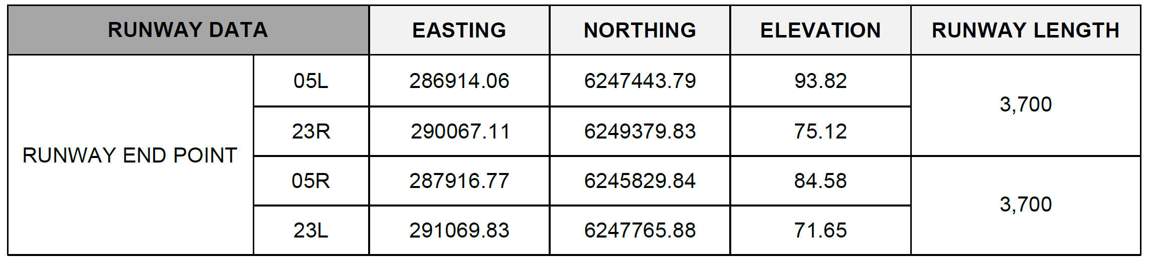
The aerodrome reference point elevation is RL 81m.
The Western Sydney Airport OLS chart is a map of the OLS area around the Airport.
Development around the OLS
Any proposed development that intrudes into the OLS must be reported to the Civil Aviation Safety Authority (CASA). It needs to be carefully planned and examined to identify any potential impacts on aircraft operations, so that the necessary steps can be taken to reduce those impacts. State Environmental Planning Policy (Precincts-Western Parkland City) 2021 requires the consent authority to consult with WSA when assessing an application for development that intrudes into the OLS.
Separate approvals are needed under the Protection of Airspace Regulations for certain activities that protrude into the OLS. These 'controlled activities’ are listed in section 182 of the Airports Act 1996 (Cth) and include:
- permanent structures (like buildings) intruding into the OLS;
- temporary structures (such as cranes) intruding into the OLS; and
- any activities that cause intrusions into the OLS through glare from artificial light or reflected sunlight, air turbulence from stacks or vents, smoke, dust, steam or other gases or particulate matter.
Some proposed structures (both permanent and temporary) around the Airport may be exempt under the Protection of Airspace Regulations, but should still be referred to WSI.
The height of the OLS surface – relating to any land affected by those surfaces – is illustrated in the Tool. This is just an estimation of ground level elevations, so a development proposal will need to be accompanied by a detailed site and topographic survey to determine actual ground levels.
- The National Airports Safeguarding Framework
Land use around WSI has been carefully planned in-line with the National Airports Safeguarding Framework (NASF) to protect the safe, 24/7 operations and long-term growth of the airport, while delivering its full benefits to Western Sydney.
The NASF gives guidance on land use considerations that may affect aviation operations by:
- requiring that noise-sensitive land uses be located outside of areas affected by aircraft noise;
- locating buildings to avoid wind shear and turbulence;
- locating wind turbines appropriately;
- ensuring lighting does not distract or confuse pilots;
- maintaining an obstacle-free operational airspace;
- ensuring off-airport development doesn’t impact the communication navigation and surveillance equipment; and
- managing land uses in public safety areas.
The NASF includes a set of principles that provide information, guidance and recommendations around airport safeguarding – to encourage better planning outcomes on and around the airport.
Please see the full framework and guidelines.
- The State Environmental Planning Policy (Precincts-Western Parkland City) 2021
The NASF has been implemented through the State Environmental Planning Policy (Precincts-Western Parkland City) 2021 (SEPP), which began on 1 October 2020.
The SEPP sets out the land use and planning controls for the 11,200 hectare area surrounding the Airport, known as the ' Western Sydney Aerotropolis'. It aims to facilitate and promote the Aerotropolis’ sustainable, transformational development – while making sure that this development aligns with the long-term growth and development of a 24/7 Airport. Any development application on land that’s within the Western Sydney Aerotropolis, or within 30km of the airport site should carefully consider the SEPP and the airport safeguard clauses.
The SEPP is complemented by the Western Sydney Aerotropolis Development Control Plan (DCP) Phase 2 and accompanying technical documents including the Aviation Safeguarding Guidelines for the Western Sydney Aerotropolis and surrounding areas.
See the complete Western Sydney Aerotropolis Planning Package.
- Wildlife
It’s just not just buildings and structures that influence how efficiently an airport operates. The congregation of wildlife – particularly birds and bats – can lead to wildlife strikes, which might cause significant delays and cancellations of flights, damage aircraft and even potentially injure pilots and passengers.
Some land use, embellishments, drainage basins and landscaping have the potential to attract wildlife, which can then migrate onto the Western Sydney Airport site or into flights paths. Which is why wildlife buffer zones have been carefully planned and implemented around the Airport.
The wildlife buffer zones have been mapped within a 3, 8 and 13 km radius of the Airport's runways. Under the SEPP and the Western Sydney Aerotropolis DCP:
- Certain land uses are prohibited within the 3km buffer zone;
- Development applications for specified uses on land within the 13km buffer zone need to be accompanied by a wildlife hazard assessment and wildlife management plan, incorporating relevant mitigation and monitoring measures; and
- Development applications for specified uses on land within the 13 km buffer zone must be accompanied by a waste management plan.
The prohibited and specified land uses are listed in the SEPP.
If your land is within a 13 km radius of the Airport, you should double-check whether or not you’re required to lodge a wildlife hazard assessment and wildlife management plan with your development application. If so, you might want to get some extra advice from a suitably-qualified consultant – like an ornithologist or biologist – while you prepare your wildlife hazard assessment and wildlife management plan.
- Lighting and reflectivity
Pilots rely on specific patterns of aeronautical ground lights (like runway light and approach light), during bad weather or nighttime hours. These lights are essential for helping pilots to align their aircraft with the runway and land safely – and why we need to be mindful of any other lighting in proximity to the Airport that can could cause glare, distraction or confusion to pilots.
The area where lighting could impact safe aircraft operations is defined in four Lighting Intensity Zones – in immediate proximity to the runways and a six-kilometre radius of the Airport for certain other developments. The Lighting Intensity Zones are referred to as Zones A-D and each have restrictions on lighting intensity/light spill.
Any land mapped within the lighting intensity area of the SEPP which incorporates significant new lighting and/or coloured lights (whether temporary such as part of construction or permanent) needs to be referred to WSA. Examples of this kind of lighting include (but aren’t limited to), stadium flood lighting and construction lighting.
Buildings should also consider reducing reflected sunlight in their design, to avoid distracting pilots.
It’s recommended that you:
- get professional advice if you’re designing a development within the lighting intensity area of the SEPP that will incorporate significant new lighting and/or coloured lighting; and
- consider the principles in Guideline E of the NASF Framework when designing your development.
You can find out more in the Western Sydney Aerotropolis planning controls.
- Noise
Airports come with certain levels of expected noise exposure – and WSI is no exception. To plan for this, the Australian Noise Exposure Concept (ANEC) has identified areas expected to be affected by aircraft noise, based on the runway direction and indicative aircraft flight paths. These are shown in the Tool and the Noise Exposure Contour Map of the SEPP.
The coloured areas shown on the map are noise exposure contours, displayed in representative units of 20, 25, 30 and 35+. The higher the contour numbers, the higher the levels of noise exposure. These units aren’t decibel measurements – they’re representative units generated from a noise model which builds in:
- aircraft types and performance
- points of origin and destination
- noise level and pitch
- the number and time of movements.
The ANEC contours aren’t flight paths and properties outside of the ANEC contours may still experience aircraft noise. You can find out more about the preliminary flight path design process on the Department of Infrastructure, Transport, Regional Development and Communications website, or by using the Aircraft Overflight Noise Tool here.
Managing and reducing aircraft noise
The most effective way to reduce the impact of aircraft noise is through careful land use planning. The SEPP aims to support this – by prohibiting noise-sensitive development in certain areas and requiring some buildings meet specified design standards.
It's worth using the Tool and considering the Noise Exposure Contour Map in the SEPP before lodging a development application – so that you can be sure your proposed development meets any noise impact requirements.
- Windshear and turbulence
Windshear (changes in wind speed and/or direction between two points) and turbulence (rapid changes in wind speed and/or direction at a fixed point) can both affect the airport’s operations – including aircraft stability during landing or take-off.
Because the size, shape and locations of buildings near the airport have the potential generate both windshear and turbulence, we’ve put together a Wind Shear Map that outlines windshear assessment trigger areas. Any application which proposes development in one of these trigger areas and falls within the 1:35 surface (ie. structures that have a distance to the runway that’s less than 35 times their height) will need to be referred to WSA for consultation (in accordance with clause 20 of the SEPP).
It’s recommended that these development applications be accompanied by a windshear and turbulence risk assessment that has been prepared by a qualified wind engineer.
Take a look through the Western Sydney Aerotropolis planning controls and NASF Guideline B for more information.
WSI’s airport safeguarding information
Please note that the information on airport safeguarding is for guidance purposes only and may change. We make no representation or warranty about the accuracy or completeness of the information, or that it has been audited or verified. You accept responsibility for the interpretations, opinions or conclusions that you form after examining this information.
The information provided on WSI's website is not professional advice. It’s recommended that any person proposing to develop land seeks independent professional advice relating to their development.
WSI doesn’t guarantee that the information is correct or up to date – and accepts no liability for any loss of any kind after relying on the information provided or obtained through our website.